Skip to content
No results
  • News
  • Events
  • Projects
  • Business
  • Partner cities
    • Chattanooga, United States of America
    • Montabaur, Federal Republic of Germany
    • Gennevilliers, French Republic
    • Comune di Silvi, Italian Republic
    • Bystřice nad Pernštejnem, Czech Republic
    • Gmina Boguchwała, Republic of Poland
    • Gmina Kożuchów, Republic of Poland
  • Friendly municipalities
    • Cities of Marlow and Rugby, United Kingdom
    • Valmiera, Republic of Latvia
    • Kashihara, Japan
  • Industrial Park
  • Steel Dream
  • Interview
  • Friends
  • Publications
  • Master plan
  • Trostyanets city hromada
  • Editorial Policy
  • Trostyanets City Council
Trostyanets

Development of Global Partnerships

Login
Partners
  • News
  • Events
  • Projects
  • Business
  • Partner cities
    • Chattanooga, United States of America
    • Montabaur, Federal Republic of Germany
    • Gennevilliers, French Republic
    • Comune di Silvi, Italian Republic
    • Bystřice nad Pernštejnem, Czech Republic
    • Gmina Boguchwała, Republic of Poland
    • Gmina Kożuchów, Republic of Poland
  • Friendly municipalities
    • Cities of Marlow and Rugby, United Kingdom
    • Valmiera, Republic of Latvia
    • Kashihara, Japan
  • Industrial Park
  • Steel Dream
  • Interview
  • Friends
  • Publications
  • Master plan
Trostyanets

Development of Global Partnerships

Land plot within the Trostyanets industrial park on Naberezhna Street with an area of ​​3 hectares

  • Avatar photoVolodymyr Zlepko
  • 09.04.2021
  • Business

    Green field type land plot within the Trostyanets industrial park.

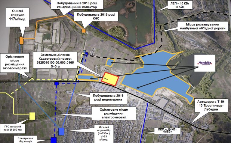
    The shape of the land plot is determined by the relevant land management documentation. The land plot is included in the national cadastral system, has a specific area, dimensions and coordinates with the assigned cadastral number 5925010100:00:003:0165.

    The relief is gentle.

    The mark above sea level is 146.3 m.

    The difference between the highest and lowest elevations of the plot is 3.2 m. From the north and east, the land plot borders on the land plot with the cadastral number 5925010100:00:003:0166.

    Classification of the type of intended purpose of the land plot: 11.02 – for the placement and operation of main, auxiliary and auxiliary buildings and structures of processing, machine-building and other industrial enterprises.

    Form of land transfer to the investor: Lease for up to 49 years with the right of subsequent redemption.

    The approximate cost of selling the land plot is 50-70 UAH. per 1 m2. An accurate calculation of the cost of selling the land plot is possible only after the preparation of an expert monetary valuation of the land.

    The approximate normative monetary valuation of 1 m2 is 100 UAH., respectively, the total normative monetary valuation of the land plot will be 1593000 UAH.

    The annual rent when establishing the minimum rent (3% of the normative monetary valuation of the land) will be 47790 UAH (or 3.00 UAH. per 1 m2).

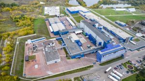
    The distance to the railway station “Smorodyne” of the Southern Railway, which is located in the city and is one of the significant railway hubs of the Sumy region, is 3.6 km. However, at a distance of 30 m from the southern border of the land plot, there is a railway line serving PJSC “Mondelis Ukraine”.

    Land_plot_Greenfield_3_haDownload
    Tags
    # Industrial Park
    Share on Facebook Share on X (Twitter) Share on Telegram
    Avatar photo
    Volodymyr Zlepko

    Deputy Mayor for Economic Development, Budget, Investments, Entrepreneurship, Municipal Property Management, and Land Relations (since 2017). He graduated from Sumy National Agrarian University with a degree in Enterprise Economics and received the qualification of economist-organizer.
    He started his professional career at the Trostyanets City Council in 2006, working in the areas of legal compliance, control of local taxes and fees, and economic development of municipality.
    In 2015–2017, he headed the Department of Economic Development, Investment Attraction, and International Cooperation of the city council. In this position, he coordinated activities related to attracting investments, developing international cooperation, supporting entrepreneurship, and implementing strategic directions for community development.

    Articles: 17

    Development concept of the Industrial Park “Trostyanets”

    Land plot within the Trostyanets Industrial Park on Naberezhna Street with an area of ​​1.593 hectares

    Land plot within the Trostyanets industrial park on Naberezhna Street with an area of ​​7 hectares

    our partners

    • Video
    • Documents

    • Trostyanets city hromada
    • Editorial Policy
    • Trostyanets City Council

    Municipal web-portal "Global Trostyanets" of Trostyanets city hromada was founded in May 2026 as a quick response and gratitude to all our international partners who helped our hromada survive after the occupation in 2022 and develop today. To some extent, this is a unique web resource, which has no analogues in Ukraine.

    Trostyanets is becoming an example of high-quality reconstruction and resilience. Financial support from the state and international partners has given us the chance to restore the housing stock, equip premises for the accommodation of displaced persons, create modern medical institutions, launch the educational process, revive and develop the municipal sphere.

    Today we have already demonstrated that restoration is not only about rebuilding buildings. It is the path to a qualitatively new level of life for municipality! We have become an example for the country and a convincing signal for foreign donors: aid brings tangible changes.

    Contact information

    • Opening hours: 9AM - 5PM
    • Website: Trostyanets City Council, Ukraine
    • Address: 42600, Trostyanets city, Myru str., 6
    • Email: mail@trostyanets-miskrada.gov.ua
    • Telephone: +380 545 85 13 80

    Copyright © 2026 - Global Trostyanets